Property Record
5550 N Highway 51 N, Millington, TN 38053
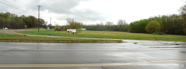
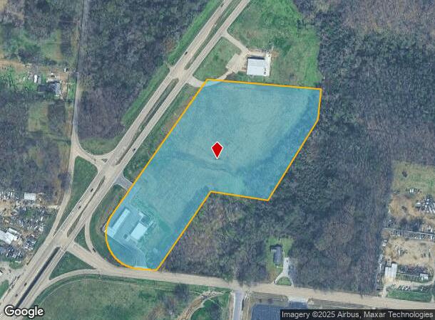
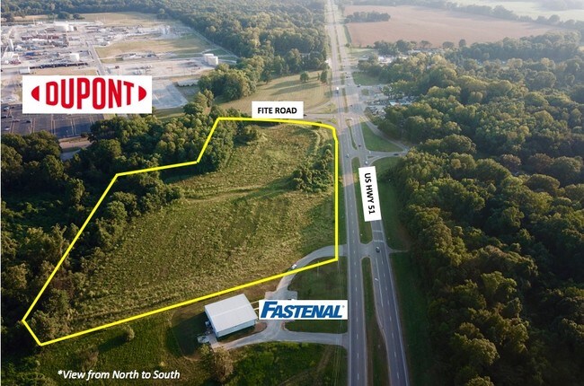
This Property Is For Sale
NEARBY LISTINGS FOR SALE OR LEASE
-
-
View all Millington listings for sale on LoopNet.com
Property Detail
5550 N Highway 51 N
Memphis, TN-MS-AR
Thomas J Branch Subdivision
D0-135-0-0148
ES HWY 51 COR FITE RD NE
Storebuilding
Shelby
AE
Tennessee
47157C0165F
5
2024
9.38 AC
2025
North
020302
Memphis
3,016 SF
DEMOGRAPHICS near 5550 N Highway 51 N
1 Mile
3 Mile
5 Mile
2024 Total Population
225
13,619
66,120
2029 Population
221
13,497
65,600
Pop Growth 2024-2029
(1.78%)
(0.90%)
(0.79%)
Average Age
43
36
36
2024 Total Households
98
4,870
23,369
HH Growth 2024-2029
(2.04%)
(1.01%)
(0.90%)
Median Household Inc
$39,499
$33,767
$40,991
Avg Household Size
2.30
2.70
2.70
2024 Avg HH Vehicles
2.00
2.00
2.00
Median Home Value
$187,499
$88,625
$99,474
Median Year Built
1973
1974
1972
Nearby Places
- Restaurants
- Banks
- Shops
- Fitness
- Groceries
PUBLIC TRANSPORTATION
AIRPORT
Memphis International
DRIVE
WALK
Distance
Memphis International
27 min
19.3 mi
Freight Ports
Port of Shreveport
DRIVE
WALK
Distance
Port of Shreveport
409 min
377.9 mi
Nearby Properties
Address
Land Use
TOTAL SIZE
Lot Size
Zoning
Address
Land Use
TOTAL SIZE
Lot Size
Zoning
917,056 SF
65.53 AC
EMP
Address
Land Use
TOTAL SIZE
Lot Size
Zoning
22,798 SF
9.63 AC
RU-3
Address
Land Use
TOTAL SIZE
Lot Size
Zoning
336,821 SF
196.54 AC
IH
Address
Land Use
TOTAL SIZE
Lot Size
Zoning
201,722 SF
64.13 AC
EMP
Address
Land Use
TOTAL SIZE
Lot Size
Zoning
75,401 SF
309.54 AC
IH
Address
Land Use
TOTAL SIZE
Lot Size
Zoning
152,631 SF
31.59 AC
IH
Address
Land Use
TOTAL SIZE
Lot Size
Zoning
32,116 SF
7.61 AC
R-6
Address
Land Use
TOTAL SIZE
Lot Size
Zoning
350,258 SF
388.54 AC
IH
Address
Land Use
TOTAL SIZE
Lot Size
Zoning
28,054 SF
7 AC
RU-3
Address
Land Use
TOTAL SIZE
Lot Size
Zoning
23,730 SF
342.10 AC
IH
Address
Land Use
TOTAL SIZE
Lot Size
Zoning
236,244 SF
11.24 AC
EMP
Address
Land Use
TOTAL SIZE
Lot Size
Zoning
11,645 SF
36.87 AC
RU-2
Address
Land Use
TOTAL SIZE
Lot Size
Zoning
63,815 SF
30 AC
IH
Address
Land Use
TOTAL SIZE
Lot Size
Zoning
124,390 SF
40 AC
IH
Address
Land Use
TOTAL SIZE
Lot Size
Zoning
154,700 SF
9.73 AC
IH
Address
Land Use
TOTAL SIZE
Lot Size
Zoning
95,716 SF
9.15 AC
IH
Address
Land Use
TOTAL SIZE
Lot Size
Zoning
40,170 SF
7.94 AC
RU-3
Address
Land Use
TOTAL SIZE
Lot Size
Zoning
14,416 SF
3.30 AC
R-8
Address
Land Use
TOTAL SIZE
Lot Size
Zoning
39,912 SF
31.16 AC
IH
Address
Land Use
TOTAL SIZE
Lot Size
Zoning
26,551 SF
303.88 AC
CA
Address
Land Use
TOTAL SIZE
Lot Size
Zoning
17,967 SF
2.47 AC
R-6
Address
Land Use
TOTAL SIZE
Lot Size
Zoning
68,117 SF
10.85 AC
IH
Address
Land Use
TOTAL SIZE
Lot Size
Zoning
50,056 SF
10.31 AC
IH
Address
Land Use
TOTAL SIZE
Lot Size
Zoning
4,752 SF
7.02 AC
EMP
Address
Land Use
TOTAL SIZE
Lot Size
Zoning
66,042 SF
15.40 AC
RU-2
Address
Land Use
TOTAL SIZE
Lot Size
Zoning
42,065 SF
50.06 AC
IH
Address
Land Use
TOTAL SIZE
Lot Size
Zoning
145,100 SF
25.50 AC
IH
Address
Land Use
TOTAL SIZE
Lot Size
Zoning
299,946 SF
100.04 AC
IH
Address
Land Use
TOTAL SIZE
Lot Size
Zoning
14,179 SF
8.70 AC
R-6
Address
Land Use
TOTAL SIZE
Lot Size
Zoning
46,528 SF
IH
The World's #1 Commercial Real Estate Marketplace
Connect with us
© 2025 CoStar Group
The information above has been obtained from sources believed reliable. While we do not doubt its accuracy we have not verified it and make no guarantee, warranty or representation about it. It is your responsibility to independently confirm its accuracy and completeness. Any projections, opinions, assumptions, or estimates used are for example only and do not represent the current or future performance of the property. The value of this transaction to you depends on tax and other factors which should be evaluated by your tax, financial, and legal advisors. You and your advisors should conduct a careful, independent investigation of the property to determine to your satisfaction the suitability of the property for your needs.